Showing posts with label Pottstown Metropolitan Area Regional Planning Committee. Show all posts

Thursday, February 27, 2020

Regional Planners Eye Intersection Improvements


Traffic and intersection improvements were the words of the night Wednesday as the Pottstown Metropolitan Regional Planning Commission reviewed two studies -- one in the works and one already complete -- on the subjects

Last January, the regional planners received a completed report from the multi-state Delaware Valley Regional Planning Commission (DVRPC) on the 18 worst intersections in the eight municipalities that comprise the local regional planning group.

Intersections in Pottstown in need of improvement.
John Cover, acting director of the Montgomery County Planning Commission, said "I don't want this study to sit on a shelf, I'd like to see a success story come out of it."

As a he result, he urged the planners to review the list and single out a few projects for which funding could be sought. Lower Pottsgrove representative Tom Troutman said he would like to see some intersections get better lighting.

He suggested two intersections on Bleim Road, one with New Hanover Square Road and the other with Pleasantview Road.

New Hanover Supervisor Kurt Zebrowski agree, and noted that the intersection of Route 73 and Middle Creek Road would be a good candidate for such treatment.

Pottstown Councilman Ryan Procsal suggested improvements to the intersection of East High Street and Armand Hammer Boulevard, a busy intersection in front of Armand Hammer Boulevard.

Price estimates for the project range from $20,000 to $300,000.

Ultimately, the planners agreed with Cover's suggestion that an expert from Montgomery County be invited to the next meeting to outline how Montco 2040 Implementation Grants county grants geared toward infrastructure can be best obtained, and which intersections stood the best chance of getting funding.

This map of peak traffic at intersections along High Street shows the highest volumes in the afternoon at Rupert Road, at far right, and Armand Hammer Boulevard, further left.
In the meantime , DVRPC has engaged in a more focused study -- of the High Street corridor from the Berks County line to the Limerick Township line.

An progress report offered up last night indicated that DVRPC has conducted counts of vehicles, heavy vehicles, pedestrians and bicycles; turning movements parking capacity and crosswalks. Crash diagrams and rates are still being developed. The first public meeting on the study will be scheduled in May.

In the meantime, the traffic count indicates that the busiest intersections are during the afternoon peak
rush hour are with Armand Hammer in Pottstown and Rupert Road in Lower Pottsgrove, both of which are likely connected to westbound Route 422 commuters returning home.

This map shows the highest volume of pedestrians crossing
High Street  
occurs in the afternoon in downtown Pottstown.
The opposite is true of heavy track traffic, which peaks in the morning, with the heaviest flow again being at Armand Hammer Boulevard, followed by Berks Street and Quarry Road in West Pottsgrove.

Top bicycle traffic occurs during the afternoon peak and is centered around central Pottstown and the intersection of East High and North Hanover streets, and those streets immediately adjacent.

Not surprisingly, the same is true of pedestrian traffic, it peaks in the afternoon rush and is centered in the borough core.

A New Boat Ramp for Norco

The planners voted unanimously to endorse a letter recommending North Coventry's application for a $60,000 state grant to replace and improve the Schuylkill River bot ramp and dock in Riverside Park between the Quoit Club and Little League fields.

Perennially under repair, it was finally taken out of commission during a storm flood last year, said supervisor's Chairman Jim Marks.

He said the project was initially estimated to cost $30,000, but as the design progressed, and the need to make the facility handicapped accessible swelled the cost to $100,000.

The grant being sought from the Pennsylvania Department of Conservation and Natural Resources by the regional recreation committee would cover $60,000 of that cost, with in-kind services and cash matches from the township, the Pottstown Area Health and Wellness Foundation and the Schuylkill Highlands Conservation Landscape Initiative.

New Medical Offices and New Emergency Services Building Being Considered in Douglass (Mont.)

Douglass Township Manager Pete Hiryak told the planners that the township has seen a presentation from developers who want to build a four-story medical complex at the intersection of Route 100 and Grosser Road.

No formal plans have been submitted, but it does comply with zoning, he said.

Further, Hiryak said the township supervisors are looking at plans to demolish the aging -- and leaking -- Gilbertsville firehouse on East Philadelphia Avenue and building a new emergency services center for police and fire on the site.

Township police are currently located in the municipal building a few blocks west. The site could even include housing for ambulance services as well, he said.

Initial price estimates came in at $4 million, but the price has been cut to $2.5 million, said Hiryak.

Road Projects Delayed in New Hanover

Township Supervisor Kurt Zebrowski informed the planners that PennDOT has delayed a project to replace the New Hanover Square Road bridge, originally set to be undertaken this year.

Instead, it has been pushed back to January of 2021. It is expected to take 12 to 14 months once it gets underway.

Also delayed are the improvements to the intersection of Route 73 and Route 663 (North Charlotte Street), including a new traffic signal.

Zebrowski said the delay for the project, which was scheduled to begin this spring, "will only be a couple of months. It will still get done this year."

Following in Upper Pottsgrove's Example?

Gregory Churach told the planners that twice each year, volunteers in Upper Pottsgrove undertake a roadside clean-up under the auspices of the Ocean Conservancy, which is trying to keep litter out of the ocean.

He said a student released in January estimates that Pennsylvania has 500 million pieces of trash along its roadways. "Thirty percent of that is cigarette butts and another 30 percent is plastic wrappers," Churach said.

He said the average Pennsylvania highway as 2,500 pieces of litter per mile, and the average local road has 1,600 pieces per mile.

He asked if other townships that are part of the regional planning group might be interested in undertaking similar clean-up efforts.

Information about how that could be done will be distributed among the group for discussion at the individual municipal level.

And with that, click here to read the Tweets from last night's meeting. 

Thursday, October 24, 2019

Norco Ready to Adopt New Comprehensive Plan

Photos by Evan Brandt
North Coventry Supervisor Jim Marks shows property the township has purchased as open space to allow for the construction of a trail.

North Coventry Township is moving forward with adopting its first comprehensive plan in nearly 20 years.

The plan sets the township's vision for development and serves as the basis for zoning changes to implement that vision.

With a few suggested changes, the Pottstown Metropolitan Area Regional Planning Committee last night issued it's stamp of approval on the draft now being circulated.

North Coventry Supervisors Chairman Jim Marks told the regional planners that the last time the township completed a comprehensive plan was in 2000. Two years later, township voters overwhelmingly approved a ballot measure to impose an earned income tax to create a fund for the purchase of open space.

Since then, the township has purchased the development rights, or property outright to the tune of 1,400 acres, Marks told the planners.

Slight revisions to the comprehensive plan were made in 2006, but since then, money has been tight and it was not until Chester County provided some funding that the township once again undertook re-writing the comprehensive plan.

Development of this plan was led by an eight-member task force consisting of representatives of the board of supervisors, planning commission, and environmental advisory committee.

"The task force analyzed and evaluated pertinent information affecting land use, housing, transportation, natural resources, historic resources, and community facilities in the township," according to the plan's introduction. "Recommendations were developed by the task force to meet the challenges and opportunities identified through the planning process, and then shared with the public for review and endorsement."

Stakeholder interviews were held in September and October 2018.

A public survey was conducted in October and November, along with a public open house in November of 2018 

A public meeting was held in April 2019. The planning commission has recommended the adoption of the draft by the board of supervisors.

Public input garnered during the writing of the draft indicated a desire for more connectivity, said Marks, in the form of more trails and bike lanes.
Map showing different land uses envisioned in 
North Coventry's draft comprehensive plan.

You can download the draft, last reviewed by the supervisors on Sept. 23, by clicking this link.

The draft comprehensive plan for North Coventry calls for:
  • conserving 1,861 acres; 
  • 2,660 acres for residential conservation; 
  • 1,365 acres for rural/low density zoning; 
  • 113 acres for commerce; 
  • 323 acres for village zoning; 
  • 396 for town center zoning; 
  • 1,416 acres for suburban residential.
The township supervisors will hold an official public hearing on the plan on Thursday, Nov. 11 at 7 p.m. at the township building on South Hanover Street.

And with that, here are the Tweets from last night's meeting:

Thursday, September 26, 2019

Planners Talk Houses, Hotels and Traffic Studies

Photos by Evan Brandt
A look at the plan for 143 age-restricted homes proposed for 36 acres in Upper Pottsgrove off Kummerer Road.


Two major developments in the Pottsgrove School District, traffic studies on High Street and Gilbertsville and a surprise $70 million proposal in North Coventry were all fair game during last night's regional planning meeting.

That's what can happen when you put eight different municipalities in the same room, stuff happens.

We'll begin as they did, with the newest.

Age-Restricted Homes in Upper Pottsgrove

Located in between Farmington Avenue, Route 100 and Pine Ford and Kummerer roads, the "Kummerer Tract" is the 36-acre site of a proposed age-restricted development of 143 detached, one-story single family homes of 5,000 square feet.

The project is within the expansion area for the township's sewer system, said Township Commissioner Elwood Taylor who remains, for the moment, the chairman of the Upper Pottsgrove Planning Commission.
A Google Earth view of the Kummerer tract bounded by Pine Ford
Road in the south, Kummerer Road to the west, Farmington 
Avenue to the north and Route 100 to the east.

The project "is part of the township's long-term plan to provide tax revenue for the township and the school district without stressing services," he said.

The age restriction is likely to ensure few if any of the homes house students the school district must educate. In fact, said Taylor, once all phases of the project are completed, it is estimated it will generate $1.8 million in annual tax revenue for the school district.

With easy access to Route 100, the project will also have a smaller impact on local roads than those further from the main north/south road in the township, Taylor said.

Developer Bo Erixxon said the project will board "50 percent more open space than is required," as well as "multiple access points," some of which will align with the Summer's Grove neighborhood.

The homes will be one-story except for those where the property grade makes it practical to have walk-out basements, he said.

The project will feature a community center, trails and a community pool, he said.

Taylor said a historical homestead for which the tract is named will be preserved with the help of the developer.

It is also consistent with the type of project envisioned in the "secondary growth area of the regional comprehensive plan," said Taylor.

Sanatoga Green Changes

In the works for years, this massive mixed-use development has gone through some changes since it first got underway with a zoning change in 2014.

The $146 million project is a mix of office, townhome and apartment buildings located on 57 acres
The latest version of the Sanatoga Green plan shows 147 
townhomes on the left, 310 apartments in the center
and the medical office space on the right.
off Evergreen Road opposite the Costco and Limerick outlets.

The township commissioners have granted preliminary approved the first of three phases, the construction of 147 townhomes.

But there have been changes, including a reduction of housing units from a high of 490 to 457, achieved entirely by a 35-unit reduction in the number of apartments.

In addition to reducing the number from 343 to 310, the developers have also reduced the number of buildings in which those apartments will be located from 17 to five.

Another change is the removal of a planned 108-room hotel, which was to be built in the second phase along with a 50,000 square foot medical office building. Instead, the project's office space, which is the second phase, will not include 120,000 square feet of medical office space, said Montgomery County planner Marley Bice.

Traffic Studies and Then Some

The regional planners are now in possession of the final version of a $65,000 study of the region's 18 worst intersections by the Delaware Valley Regional Planning Commission, and how to improve them.

And the timing could not be better, said  John Cover, the assistant director of the Montgomery County Planning Commission.

This traffic study recommends improvements to 18 
of the region's worst intersections.
The county has instituted a $5 fee on car registrations that will help fund a $1 million pool of money for road and bridge improvement projects.

"There are a number of projects in this report that would be very competitive for that funding," Cover told the planners.

Because they would be applying as a region, and the study has already been done, chances of winning some funding would be high, particularly given that the most expensive project outlined in the study is about $65,000, said Bice.

There is a local match for the funding, but "the money is there and your residents are already paying for it, why not go for it?" said Cover. "I'd like to see some of this money go to the western part of the county."

The DVRPC's next project will be a traffic study of High Street from the Berks County line through Sanatoga, said Bice.

Traffic counts will begin shortly and the goal of the study, to be completed by June 2021, will be to beautify the street, and to improve traffic flow.

Traffic is also at the heart of a land use study by Douglass (Mont.) Township that was reviewed last night. That study, which concludes 748 new housing units will be built in the township's southern portion by 2035, will become the basis for traffic fees charged to developers.

In addition to the inclusion of the long-discussed "Market Street" project in Gilbertsville, the study also includes the development of the 236-unit Zern tract on 285 acres between Jackson Road and Route 100.

Township Manager Peter Hirkyak said the first phase of the Zern tract project, which will see the
This map shows the Zern tract project on the top right, and the
much larger Gambone commercial project below it along
Route 100. The "L" shaped road is the proposed Market Street.
construction of 72 townhomes, has already begun. Under the terms of a resolution adopted in May setting deadlines for the project, 80 more homes must be started by August of 2021; and the final 82 townhouses must begin construction by April, 2023.

Even before the new traffic impact fee schedule is set, the Zern Tract will contribute $329,293.02 toward the construction of Market Street, the long-envisioned road parallel to Route 100 and Jackson Road.

Market Street and will not be constructed until a much larger commercial development along Route 100 and owned by the Gambone development family comes to pass.

As proposed now, that project includes two four-story hotels of 100 rooms each; a 147,000 home improvement store, a 64,000 square-foot outpatient facility; another 100,000 square feet of retail and several smaller office buildings.

But that project is years away from fruition, according to township officials.

$70 Million in North Coventry

West-Mont Christian Academy on South Hanover Street.
There isn't much to tell you about this startling headline.

It is based on comments North Coventry Supervisors Chairman Jim Marks made at the end of last night's meeting.

He said at Monday's meeting, the board of supervisors was approached by officials from West-Mont Christian Academy, which occupies the former North Coventry Elementary School property adjacent to the township building on South Hanover Street.

They said the school is in contact with an investor willing to spend as much as $70 million to build a hotel, conference center, and possibly some housing on the site.

"It's in the very early stages, but if it comes to fruition, it will definitely be a development of regional significance," said Marks in what may well be the understatement of the week.

That's all we got folks. Here are the Tweets from the meeting:

Thursday, June 27, 2019

Report Takes a Look at Pottstown Region's Health


This won't be a long one folks, because the meeting of the Pottstown Metropolitan Regional Planning Commission itself wasn't long.

And there won't be another for some time seeing as they are taking off July and August.

The main event was a presentation by Craig Colistra, the program officer for recreation and health at the Pottstown Area Health and Wellness Foundation.

He was presenting facts from the foundation's 2018 Community Heath Needs Assessment and it was an interesting overview.

Colistra said the full report is on the foundation website, but I couldn't find it. I emailed them last night and am hoping to get a look at it soon.

There were some interesting facts that are tangential to health, such as population, race, median income, poverty and the like.

It will surprise no one to learn, for example, that Pottstown has the highest diversity level (Douglass (Mont.) is more than 90 percent white); the lowest median income and the highest number of families in poverty. Yay us.

Here are some of the takeaways:

  • About 10 percent of the people who live in the eight towns represented by the committee (see photo at top) lack health insurance and others have trouble accessing care even if they do.
  • 14 percent do not seek care when they are sick and 15 percent do not get medicine they need, mostly due to cost.
  • 55 percent exercise three times a week; event fewer, 24 percent, eat fruits and/or vegetables four times a week; but fewer of us are drinking sugary drinks, less than the rest of Southeast PA.
  • Even though our obesity level is close to the U.S. health target at 30 percent, we nevertheless have a higher rate of diabetes (14 percent); but less high blood pressure and high cholesterol than the wider area.

One of the reasons I attend these meetings, other than the sparkling conversation, is the reports from all eight of the municipalities represented. You may have noticed there are not as many Mercury reporters as there used to be and I can't be everywhere, so I often find out about things I missed.

Such was the case last night.

First, Gregory Churach announced that a developer has submitted a plan for a total of 290 age-restricted homes on the west side of Route 100 near the Farmington Avenue interchange.

The initial plan had called for some townhomes, but Churach said when the developer returned, he had changed his plans to include only single-family homes. He noted that several years ago, the zoning of the land near that intersection was changed to encourage exactly this kind of development.

And West Pottsgrove Township Commissioner Mark Green announced that at a meeting I missed, the commissioners voted to fill in the township pool, once the Colonial Pool, rather than try to sell it.

That's because the professional appraisal of the property came in at only $150,000, "less than the township put into it," said Green. The facilities restrooms and snack bar will remain, as will the pavilion, but the pool itself will be filled in.

The property is to be turned into a park with a playground for children, said Green.

And with that, here are the Tweets from the meeting:

Thursday, April 25, 2019

Parks, Open Space Preservation, New Development

Photo by Evan Brandt
This proposed development off Holly Road, behind the Gilbertsville Giant off Route 100, would have 190 dwelling units and 28,130 square feet of commercial space as currently proposed.


Regional planners deal with everything from the big picture, like entire county comprehensive plans, to details like "where are the storm basins?"

Last night was quite a bit of both at the Pottstown Metropolitan Regional Planning Commission, which is comprised of eight municipalities, including two in Chester County.

Which explains why Carol Stauffer, assistant director of Chester County Planning Commission, was in the house updating the planners on Landscapes 3, the county's comprehensive plan. The first plan was 1996, the second was in 2009.

We've written quite a lot about that already here at Digital First Media, oops, I mean MediaNews Group, so I won't go into it here.

Because we've already gone into it here.

State Grant Applications Supported


At a lower level, the planners approved letters of support for two park and preservation projects.

They voted unanimously to support a $250,000 grant application by West Pottsgrove for further
West Pottsgrove has been steadily making improvements to
Ralph P. Murgia Park off Manatawny Street.
improvements to Murgia Park, specifically the construction of a pedestrian bridge over Manatawny Creek, which would connect the park to a trail planned to come upstream from Memorial park in Pottstown.

The bridge would also give access to a small platform being planned by the Colebrookdale Railroad to give riders a place to get off and visit the Sly Fox Tap Room and Manatawny Still Works on Circle of Progress.

That grant, if awarded, would come from the Pennsylvania Department of Community and Economic Development.

A unanimous vote will also provide a letter of support from the regional planners for an effort to preserve Camp Laughing Waters, a 455-acre Girl Scout Camp in New Hanover and Upper Frederick Township, south of Route 73 between New Hanover Square Road and Fagleysville Road.

There are plans for a trail network that would connect to both the Perkiomen Trail and Sunrise Mill and the proposed Swamp Creek Trail.

As The Mercury reported earlier this month, Montgomery County has already agreed to put up $2,767,000 toward the $3,917,000 price of the conservation easement and another $1,150,000 grant is being sought from the Pennsylvania Department of Conservation and Natural Resources.

It is this second DCNR grant which the regional planners voted to support.

Mini Grants Awarded


The regional recreation program, which was born out of the regional planning committee, also awarded five "mini-grants" of $25,000 each for the third year in a row, Montgomery County Planner Marley Bice announced.

(You can learn more about that program by clicking here.)

In West Pottsgrove, the mini grant will pay for even more improvements to Murgia Park.

"This project will extend the Tri-County Trail system's Manatawny Trail to the west from the recently installed pedestrian bridge over the Goose Run stream. A pavilion and access path for community use on the west side of Goose Run stream will also be constructed," according to the site.

In North Coventry, the mini grant will pay for improvements at Riverbend Park, at the intersection with Laurelwood and River roads.

It will pay for "installation of a new playground for the 2-5 years old age group in proximity to an existing pavilion, swing set, and softball field. A paved ADA-accessible walkway and two ADA parking spaces are also proposed. A future phase will install a new playground for the 5-12 years old age group."

In East Coventry, the mini grant will be spent at Ellis Woods Park, located behind the township building.

It will "improve Ellis Woods Park by constructing an additional two pickleball courts to complement the existing court and allow for more play at once. Green stormwater management will also be constructed."

In Douglass, the mini grant will be spent at Douglass Park, located behind that township's municipal building.

The grant will "redevelop and replace older play equipment in Douglass Park. Remove two old swing sets, expand the existing play area to the north and south with new safety surfacing and plastic boarders, add a new swing set, construct an accessible pathway and five new park benches. Replace the pavilion with a new 30' x 50' pavilion with blacktop pad."

And in Pottstown, the $25,000 mini grant will pay for improvements at Potts Drive Park, located in the area west of Route 100 known locally as "the manor" and behind Wal-Mart.

"This project will include resurfacing and lining of an existing basketball court; installation of new uprights and hoops; installation of a three-bay swing set and safety surfacing; and installation of an ADA-accessible pathway connecting the parking lot to the new park features," according to the application.

Two Projects in Douglass


The planners also reviewed two projects in Douglass about which, I am afraid I am somewhat short of details.

I know about the project in the photo re-produced here again.

It is a plan for a parcel off Holly Road, between the Giant Shopping Center off Route 100 and Clover Lane, which a dog-leg that cuts behind Giant out to County Line Road.

It is a Gambone project and calls for 190 dwelling units, 166 of them townhouses, as well as 28,130 square feet of commercial space, 163 parking spaces, 34,240 square feet of recreation space and 17.35 acres of open space along the northern border. 

Ed Reitz, who sits on the Douglass Township Planning Agency, said the project has been around for several years and recently became active yet. It does not yet have any planning agency or township supervisor approvals.

It is located in the township's "growth area," as outlined in the regional comprehensive plan adopted in 2015.

After some discussion, the planners decided to send a letter to Douglass expressing concern that the project have adequate parking, stormwater controls and a pedestrian crossing on Holly Road.

The other project has spurred a request for a zoning change to allow "active adult community" to be included as an allowed use in the township's "neighborhood mixed use overlay district," according to a legal notice published April 23 in The Mercury.

Reitz said the project is partially in Colebrookdale Township in Berks County and partially in Douglass (Mont.).

He said it is near the intersection of Mill Street and Sweinhart Road (shown at left) which runs parallel to Route 100 near the Berks County line.

According to the proposed ordinance reviewed by the planners, the overlay district can only be applied to properties of 25 acres or more with public water and sewer in either the R-3 Residential District or the M-1 Office and Light Industrial District.

It would allow for the construction of community centers and clubhouses in the Active Adult Communities as well as "at least one village green area with a minimum area of 15,000 square feet," as well as picnic groves, gazebos and park benches.

According to the legal notice, the Douglass township Supervisors will conduct a public hearing on the proposed zoning change at their meeting on Monday, May 6 at 7 p.m. at the township building, 1320 E. Philadelphia Ave. in Gilbertsville.

That's all I know for know.

And with that, here are the Tweets from the meeting.

Thursday, February 28, 2019

Pottstown Regional Planners Urged to Join Others Aiming for 100% Renewable Energy Usage by 2050

Photos by Evan Brandt

This map shows communities across the country that have resolved to run on 100 percent renewable energy by 2050.


Not everything the Pottstown Metropolitan Area Regional Planning Committee deals with is zoning and traffic and land use.

Sometimes the planning part deals with more global subjects, like climate change, and how we can plan locally combat it.
Bill Sabey, left, and Jim Wylie.

Last night was one of those nights.

The planners were visited by two volunteers -- Jim Wylie and Bill Sabey -- from the Sierra Club's "Ready for 100%" renewable energy initiative.

They were there to talk to the planners about encouraging their municipalities to take whatever steps they can be convinced to take to change their energy habits -- that goes for the municipalities themselves as well as the residents they represent.

Montgomery County towns considering the resolution
If they do so, they would not be the first.

To date, the Chester County municipalities of Phoenixville, West Chester, Downingtown, Uwchlan, Kennett, and East Bradford have all adopted resolutions committing to 100 percent clean, renewable electricity by 2035, and 100 percent renewable energy for heat and transportation by 2050.

In Montgomery County Lansdale, Bridgeport, Conshohocken, Norristown and Plymouth are all considering similar resolutions, Sabey said.

Jon Lesher, principal environmental planner for the Montgomery County Planning Commission, told the regional planners that the county's renewable energy efforts have focused primarily on solar and geothermal, where it is viable.
Solar projects throughout Montgomery County.

There has not been much focus on wind energy here simply because, the last several days excepted, eastern Pennsylvania is not an area known for sustained regular winds.

He said to date, Montgomery County has 1,865 solar projects.

Moving forward with small achievable steps will make the goal of relying on 100 percent renewable energy possible, said Sabey.

In the first five years, small steps like making homes more energy efficient, conducting energy audits, researching grants and energy alternatives are all part of the plan, said Wylie.

The savings that can be generated by such changes can be used to as a nest
egg for future projects.

Pottstown Borough Council President Dan Weand noted that when the borough built its new $4 million public works garage, it was sure to put nodes on the roof to accept solar panels.

"But budget constraints made it too much to afford right away," he said.

Sabey said doing an energy audit on borough hall and other borough facilities could generate savings, "but don't put that in the general fund. Put it into a dedicated energy fund and when grants come along that need a 50 percent match, you'll be ready," he advised.

A study by the Delaware Valley Regional Planning Commission 

found the 8 towns in the Pottstown region spend $169.2 million
per year on energy.
The next step, after adopting a resolution, can be to set up a team of officials, experts and volunteers -- West Chester calls theirs the "Green Team" -- to start mapping out how the sustainable energy goals can be achieved.

For example, neighborhoods can band together and get a discount from a solar panel installer if they all commit to getting panels. Philadelphia recently bid for purchasing solar power electricity and awarded it to a project in Adams County for a price of 4.4 cents per kilowatt, Wylie said.

The Delaware Valley Regional Planning Commission estimates that the eight municipalities in the Pottstown planning region spend nearly $170 million per year on energy. "Imagine if even half of that could be from renewable sources," said Sabey.

About 91 percent of that energy comes from three sources, nuclear, coal and natural gas, with solar representing 1 percent and hydro-electric 3 percent.

The alternative, Sabey said, is to endure the ever-worsening impacts of climate change without taking any action to stem them.

We are already beginning to see the impacts, he said.

Record temperatures, with some models predicting more than 40 days a summer above 90 degrees, all of which will require more air conditioning, which will require more power.

Such high temperatures also lead to things like highways buckling, as Route 422 and route 202 did last summer.

There is also a decided increase in heavy downpours in the region. No you are not imagining it.

He pointed to the fact that last year, for the first time in its 38-year history, the King of Prussia Mall was flooded by an intense rain storm.

Government records indicate that intense downpours above normal variations from 1958 to 2012 increased in the northeast states, including Pennsylvania, West Virginia and Maryland, by 71 percent.

The planners made no commitments to speak with their municipalities about moving forward with any of the suggestions made by Wylie and Sabey.

And with that, here are the Tweets from the meeting:

Thursday, January 24, 2019

Regional Planners Review More Rotten Intersections

Photos by Evan Brandt
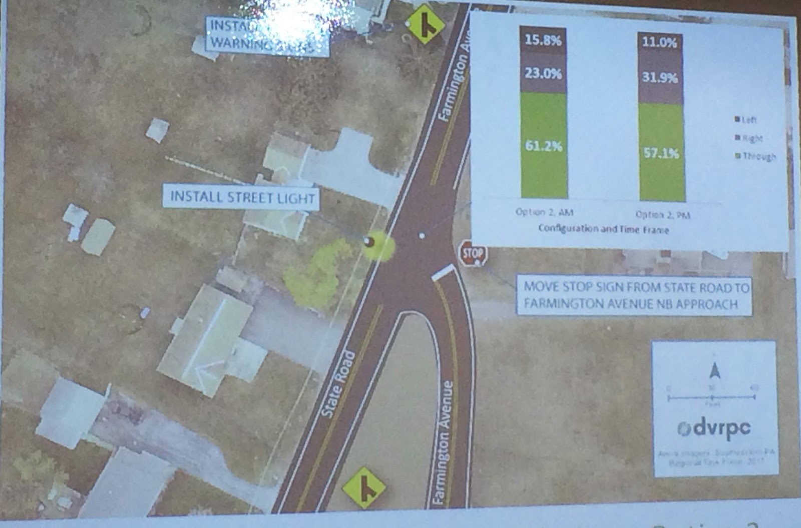
Above is one option for improving safety at the intersection of Farmington Avenue and State Road near the firehouse in Upper Pottsgrove presented Wednesday night.

At right is a second option which would be more expensive and might cause an increase in rear-end collisions which are nevertheless less likely to be serious or, worse, deadly, according to the DVRPC.


The Pottstown regional planners' tour through the region's 18 worst intersections continued Wednesday night as eight more were examined and suggestions for making them safer and more efficient were explored.

Last month, the planners looked at nine intersections in Pottstown, Lower Pottsgrove, Uppwer Pottsgrove, West Pottsgrove, New Hanover, Douglass (Mont.), North Coventry and East Coventry. Wednesday night, they looked at eight more.

The study is being conducted by the Delaware Valley Regional Planning Commission and the idea is to identify some of the smaller-scale projects that could be undertaken by the participating municipalities for minimal cost, or tasking a developer with the task.

In fact, Montgomery County Traffic Planner Crystal Gilchrist said thanks to a new initiative by PennDOT's Maintenance Department to improve communication and coordination with local municipalities, some of the simpler re-striping might be accomplished by PennDOT crews at no cost.
Improvements recommended for the intersection of Route 73
and Middle Creek Road in New Hanover.

For the most part, however, the fixes will likely be in the hands, and wallets, of local officials.

Bleim Road in Lower Pottsgrove and Middle Creek Road in New Hanover won the unofficial award for most problem intersections, three for Bleim Road and two for Middle Creek Road.

While the intersection of Middle Creek and Congo roads can be improved with some signs, striping and making it a four-way stop, traffic counts (both present and future) and the number of accidents at Route 73 and Middle Creek Road warrant some turn lanes and a traffic signal, according to the DVRPC.

A recommendation for a new alignment at Pleasantview Road
and Bleim Road in Lower Pottsgrove.
As for Bleim Road, the intersections with Route 663, Pleasantview Road and New Hanover Square Road all warrant some attention.

While the intersection with New Hanover Square Road can be improved with some better sight distance and some new striping, the best option for its intersection with Pleasantview Road is to re-aling it so it creates a T-intersection with Pruss Hill Road and install a traffic signal, according to the DVRPC.

Similarly, bad sight distance at the intersection with the busy Route 663 warrants turn lanes and a traffic signal, according to the agency.

Other intersections where improvements are needed include High Street and Sanatoga Road in Lower Pottsgrove; Route 724 and Wells Road, along with Route 23 and Bethel Church Road, both in East Coventry.

The final report is due to be provided to the regional planners at the end of June.

Here are the Tweets from the meeting:

Friday, December 7, 2018

Planners Study 9 of the Area's Worst Intersections

Crappy Photo by Evan Brandt
An example of one of the slides from last night's presentation about improving nine of the regions intersections. This one is for the intersection of Armand Hammer Boulevard and Industrial Highway in Lower Pottsgrove.


What are the Pottstown region's worst intersections and, perhaps more important, what must be done to improve them?

Those were the questions faced by the members of the Pottstown Metropolitan Regional Planning Commission Thursday night.

That's when a draft of a study of nine intersections by the Delaware Valley Regional Panning Commission was presented.

Next month, the second half of the study and data on nine more intersections will be presented.

The nine outlined list night were:

  • Manatawny Street and Grosstown Road in West Pottsgrove;
  • Manatawny Strret and Sell Road in West Pottsgrove;
  • Manatawny Street and Glasgow Street in Pottstown;
  • High Street and Moser Road in Pottstown;
  • High Street and Armand Hammer Boulevard in Pottstown;
  • Armand Hammer Boulevard and Medical Drive in Lower Pottsgrove;
  • Armand Hammer Boulevard and Industrial Highway in Lower Pottsgrove; 
  • Vaughn Road and route 724 in East Coventry
  • Hoffecker Road and Route 100 in North Coventry.

Each intersection was outlined for traffic volume and safety, along with projections for future traffic load.

Surprisingly, several of the intersections were forecast to actually have less traffic in 2020 or 2025 because planners anticipate future building will convince drivers to take different routes.

The meeting was also an opportunity to gather more information.

For example as DVRPC Planner Kathleen Whitaker outlined the problems with the intersection of Hoffecker Road and route 100, she became aware -- thanks to input from North Coventry Supervisors Chairman Jim Marks -- that the township had just received a sketch plan for a proposed 200-plus apartment complex near that corner, making the recommendation for a traffic signal all the more imperative.

Once the second half of the study is presented in January, the DVRPC will take the input back to create a final report, due in June, which each of the eight municipalities that are part of the regional planning commission can use to recommend upgrades at those intersections.

The report was funded entirely by a $65,000 allocation DVRPC made to the region.

After June, another allocation is available and Whitaker outlined some other areas that might be studied at no cost to local taxpayers.

Whitaker says possibilities include a study of High Street corridor traffic to create a model for downtown Pottstown; a school transportation study for the region; a Route 663 study from Maugers Mill Road to Route 73; 10 to 15 more intersections; a look at restoring regional rail; or ways to make better connections between adjacent housing developments.

What do you think?

In the meantime, here are the Tweets from the meeting:

Thursday, June 28, 2018

Getting Land Preservation Out Into the Open

Fuzzy Photos by Evan Brandt
Eric Jarrell, section chief of community planning for the Montgomery County Planning Commission, illustrates all the area of interest investigated in the draft Multi-Regional Greenways and Stewardship Study during the meeting Wednesday of the Pottstown Metropolitan Area Regional Planning Committee.


Perhaps the first and most important thing to remember about environmentally sensitive areas, greenways and the like, is that many of those acres are under private ownership.

As a result, there is only so much that governments and non-profit preservation agencies can do directly to ensure the protection and proper function of critical woodlands, wetlands, meadows and streams.

Now in its third year and in preliminary draft form, a study that looks at such properties in 26 municipalities over 195 square miles in western Montgomery and northern Chester counties, looks to maximize that protection at a minimum of cost.
This map shows public parks, preserved
farmland, conservation lands and even
'Main Street Greenways' in purple.

"We can't just buy every property of value," said Eric Jarrell, section chief for
community planning with the Montgomery County Planning Commission.

Jarrell was in Pottstown Wednesday to update the Pottstown Area Metropolitan Regional Planning Committee on the progress of the study since its introduction in November of 2015.

The massive undertaking, assisted by the non-profit preservation group Natural Lands and the Perkiomen Watershed Conservancy, will be in final form by the end of the year.

Not only will it contain "best practices" for specific habitats and landscape types out in the undeveloped area, but also specific ways to improve specific greenways in boroughs, villages and downtown areas, said Jarrell.

Such efforts will also help in stormwater management efforts, he said.

But it can't cover everything.

One improvement Jarrell said the study is
like to suggest, is to use vegetation to 
replace some of the "ocean of asphalt" that
surrounds the firehouse in Gilbertsville.
For example, the study group looked at 38 public parks, but there are about 300 that it didn't. So father than try to devise a specific plan for each park, it will outline the "best management practices" for areas near streams, called "riparian buffers," woodlands and the like.

And those practices will not just be for municipal or protected lands, but also those in private hands as well. Jarrell said when complete, owners of those properties believed to have important or sensitive natural features will be invited to learn how to better manage them for maximum natural benefit.

They won't be pushy, he said in response to a concern raised by New Hanover Supervisor Kurt Zebrowski. "I think we'll have our hands full just trying to meet the needs of those landowners who respond and want our help," Jarrell said.

A separate guide will be produced for the management and improvement of Main Street greenways, said Jarrell, as well as guidelines for mustering a force of volunteers who can properly undertake such tasks as plant trees and remove invasive species.

Hopefully, private landowners may be able to take advantage of such volunteer groups as well.

And with that, here are the Tweets from the meeting:

Thursday, April 26, 2018

Regional Planners Have Concerns About Plan for Massive Auction Business in East Coventry


A proposal to build an auction facility for used vehicles and heavy equipment near the intersection of Route 724 and Fricks Lock Road in East Coventry consumed most of the attention of the regional planners Wednesday night.

J.J. Kane Auctioneers, Inc., which has a facility on Conshohocken Road in Plymouth Meeting, are looking to open another location on 48 acres in East Coventry.

Screen shot from J.J. Kane Auctioneers web site.
According to its web site, the company auctions off used cars, trucks, SUVs, vans, flatbed trucks, service trucks, cranes, and construction equipment every 60 days.

The company has approached the township about building a small 4,800 square-foot office and 700,000 square-foot gravel inventory parking area where it will conduct its auctions.

Walt Woessner, who serves on East Coventry's Planning Commission and is one of two township representatives on the regional planning committee is not a fan.

"Our planning commission has had one session with this and I'm not sure how everyone else feels about it, but I think it's a disaster," said Woessner.

He said the developer's traffic study indicates no problems, adding "but then, I've never seen a developer's traffic study that finds one." 

Tours of Frick's Lock Village are offered by the East Coventry
Historical Society.
The East Coventry Historical Commission also has concerns about heavy truck traffic on Fricks Lock Road, which leads to historic Fricks Lock Village, which has been restored and at which the historical society frequently offers tours.

Then there is the traffic. All the planners noted the sharp angle of that intersection would make turns for tractor trailers carrying heavy equipment to auction difficult to say the least, not to mention the traffic on auction day.

Last but not least, the planners also expressed concern about any environmental risks to the groundwater and to the nearby Schuylkill River from vehicle fluids like motor oil or transmission fluid, "especially from older, used equipment," said Pottstown Councilman Ryan Procsal.

That said, the proposal does comply with the regional comprehensive plan in that it is in the "growth area" designated in the plan in that it is near to a major road and does not have man y residential properties nearby, said Montgomery County Planner Marley Bice, who advises the planners.

The regional planners voted unanimously to express all of those concerns to the East Coventry officials in their review of the project.

Here are the Tweets from the meeting.
 

Thursday, March 29, 2018

Regional Planners Join Call to Keep YMCA Open

The Pottstown YMCA on North Adams Street is supposed to close in June, but an increasing cry in the community is calling for it to remain open. Wednesday night, the Pottstown Metropolitan Area Regional Planning Committee joined that chorus.


One of the responsibilities of the Pottstown Metropolitan Area Regional Planning Committee is to comment on "developments of regional significance."

Usually, that charge is interpreted literally and "developments" on which they comment are the kind that come with new houses or shops, roads, storm water systems and zoning variances.

But the members of the committee, which represents Pottstown and the seven communities around it in two counties, had something to say about a developing situation in the borough for which they had no approval -- the decision by the Freedom Valley YMCA to close the local facility on North Adams Street in June.

"The closing of YMCA is absolutely an issue of regional significance," said Upper Pottsgrove Commissioner Elwood Taylor after the issue was raised by Pottstown Councilman Ryan Procsal. "It should be in Pottstown." Freedom Valley YMCA is "taking their money and not putting it where the people need it," Taylor said.

Membership in the Pottstown Metropolitan Area Regional 

Planning Committee includes officials from  eight towns.
"It's like having a centralized public library in Pottstown, it's necessary and so is the YMCA," Taylor said.

Peggy Lee-Clark, the executive director of the Pottstown Area Industrial Development Inc., or PAID, said she is on the committee formed by the YMCA to come up with recommendations for ways to continue services after the building is shuttered.

"There is some discomfort" on that committee "that the (Freedom Valley) YMCA is not really fulfilling their mission" by closing the building," Lee-Clark said.

At the suggestion of John Cover, a chief community planner with the Montgomery County Planning Commission, the local officials voted unanimously Wednesday night to issue a statement and send a letter opposing the closure and calling for the improvement or upgrading of the current facility.

Both will be written and sent by the planning commission so as not to delay the delivery of the message.

The letter will join the resolution passed by the Pottstown School Board strongly opposing the closure, a similar call by State Representatives Thomas Quigley and Tim Hennessey, as well as a similar effort, possibly pending from the Pottsgrove School Board, according to reporting in The Sanatoga Post on the meeting there Tuesday night.

Lee-Clark said the committee has been told it will cost $11 million over the next few years to bring the building up to snuff, and that $3 million is needed almost immediately to deal with issues of "deferred maintenance."

"That's about half the cost of a new building," Cover observed.

The voting concluded, Lee-Clark then said she wants to "change the narrative" that has been "appearing in the press" about the issue.

"Poverty does not define Pottstown," she said. "Albeit this is a loss, and I understand anger about how it has been handled, but it is not a crushing to the borough and I think I have to change that narrative. I don't look at it as one more blow to Pottstown," she said.

Noting that it is her responsibility to try to expand Pottstown's property tax base, Lee-Clark said "from my perspective, I have to go forward as if the building is vacant. I'm not interested in filling it with another non-profit."

While I understand that perspective, I'm afraid I am going to have to call "hogwash."

How can the person who touts Pottstown's "diversity" in PAID's marketing materials, try to minimize what the loss of the YMCA will mean to its low-income community? Maybe because it's the same person who oversaw the production of the first "I Pick Pottstown" video, which touts our "diversity," but neglects to show a single person of color.

As someone who was once a member of the YMCA; whose son learned to swim there; to play basketball there (and learned he would never be a basketball player there); who learned karate there; who met his very best friend there, I can tell you it wouldn't have happened in a "Y Without Walls," which is the snappy sounding but meaningless alternative the Freedom Valley Y is peddling here in Pottstown, all while if builds glass and steel castles in affluent Main Line suburbs.

Perhaps if Lee-Clark lived in the borough she is charged with improving, instead of going home every night a Chester County farm house, she would have a more organic understand of why closing the Y is a "crushing blow," why it is so important for families struggling to keep their kids off the streets to have a place to go, where they can be safe and have mentors.

It's not just the "low-income" community that is affected by this closure. 

The advantage of "diversity" is that it brings people of different financial, ethnic and cultural backgrounds together in shared experiences and foments understanding across financial and social divides. So if it is hurtful to the "low-income" folks in a diverse community, that means it is hurtful to the ENTIRE COMMUNITY.

It doesn't make it less important if the low-income community is disproportionately affected, it makes it MORE important because those folks are the ones already struggling under the heaviest burdens.

Pottstown's low-income community is not something to be ashamed of; not something that needs to be downplayed. They are proud hard-working people who may need some help to get by, or have fallen on hard times, or are struggling to overcome a fractured home life. They are the heart and soul of Pottstown just as much as Weitzenkorn's, Brunish's or Sunnybrook Ballroom. 

That's what "diversity" means, embracing the differences and making the most of what it has to offer, not dismissing the impact on the poor and lamenting it being showcased in the local newspaper like a community's dirty laundry.

Look, we all understand it might make marketing Pottstown to investors harder if the newspaper has a string of headlines blaring about the community being up in arms because the YMCA is abandoning its mission to help low-income communities. But that's the job Lee-Clark signed up for. It's a hard job, that's why it pays $86,000 a year, and we'll be damned if we're going to lay down and lose a vital and historic community resource just to pretty up the marketing brochure.

Maybe we should start marketing Pottstown as a place that stands up and fights for its due.

Anyhoo, enough speechifying.

In point of fact, most of the regional planning meeting was taken up with discussion of the regional trail system being planned, and the most likely portions of it to be developed first.

Also discussed was a housing development project in New Hanover near Swamp Pike and New Hanover Square Road.

You can find all of that in the Tweets below and in subsequent articles in The Mercury.

Thursday, March 1, 2018

Greenways and Traffic, Both Are Being Studied

Photo by Evan Brandt
A map of the region being covered in the Multi-Regional Greenway and Stewardship Study. It includes municipalities in the Pottstown Regional Planning Group, the Upper Perkiomen Regional Planning Group, the Central Perkiomen Regional Planning Group and the Indian Valley Regional Planning Group, 36 municipalities total


It takes a long time to study and categorize features in 36 different municipalities.

Especially when you are looking at different terrains, habitats, flora and fauna, as well as coming up with ways to best maintain them.

But that's what Natural Lands and the Montgomery County Planning Commission are doing in an effort that is now three years old, and still not complete.

The idea is to get an inventory of greenspaces in the four regions, public and private, and come up with guidelines on how best to maintain them.

The Pottstown regional planners got an update on that effort last night, and learned that the park in each township and borough studied were carefully selected for habitat, landscape and terrain type -- wetland, meadow, forest -- so that the stewardship guides would apply to any parcel of greenspace with similar characteristics.

The planners also reviewed a list of 21 roadways or intersections which are candidates for study by the Delaware Valley Regional Planning Commission, removing some, adding others.

Here are the Tweets from the meeting: