 |
| The new Schuylkill River Water Trail Guide. |
Blogger's Note: The following was provided by the Schuylkill River Heritage Area.
Do you have a paddler on your Christmas list? The Pottstown-based Schuylkill River Heritage Area may have the perfect gift.
The Schuylkill River Heritage Area has introduced a new Schuylkill River Water Trail guide designed to help paddlers plan enjoyable trips and safely navigate the Schuylkill. The newly released “A Paddler’s Guide to the Schuylkill River Water Trail,” is available exclusively through the Schuylkill River Heritage Area.
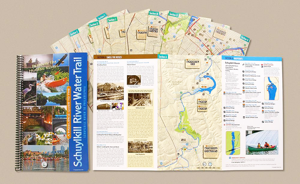
The high-quality, comprehensive guide consists of a book and set of removable maps. Both are printed on waterproof synthetic stock. The 20-page spiral-bound guidebook includes a section-by-section trip planner, as well as valuable safety information, a field guide and detailed listing of water trail landings.
A portfolio on the inside back cover holds a set of 18 tri-fold maps that can be easily removed for access on the water. The maps divide the river into 18 sections, and each map provides essential details about waypoints, hazards, river miles, points of interest and much more. Areas of cautions are clearly delineated as is information on water levels and estimated travel times.
Attractively illustrated with numerous color photographs, “A Paddler’s Guide to the Schuylkill River Water Trail” covers roughly 115 miles of the Schuylkill River, beginning in Schuylkill Haven and ending in Philadelphia just below Schuylkill Banks.
The Schuylkill River Heritage Area developed the guide in response to a growing interest in river recreation.
“In recent years, we’ve seen a dramatic increase in the number of people paddling, fishing and recreating on the river, and we expect that trend to continue,” said Schuylkill River Heritage Area Interim Executive Director Tim Fenchel.
“We put a great deal of effort into creating a first-rate water trail guide that is attractive, portable, and most importantly is painstakingly researched to ensure that paddlers of all abilities have the information they need to safely explore the river.”
The guide was designed by graphic artist Brian Swisher, an avid paddler who spent years researching and developing the content with assistance from nearly 50 contributors.
Cost is $40. For more information or to order a copy visit www.schuylkillriver.org.
The Schuylkill River National and State Heritage Area, managed by the non-profit Schuylkill River Greenway Association, uses conservation, education, recreation, tourism, and cultural and historic preservation as tools for community revitalization and economic development. For more information visit www.schuylkillriver.org.
Cost is actually $50 because they charge $10 to ship this perfectly media-mail eligible item. So plan on $50, not $40.
ReplyDeleteWas it worth the $50?
Delete